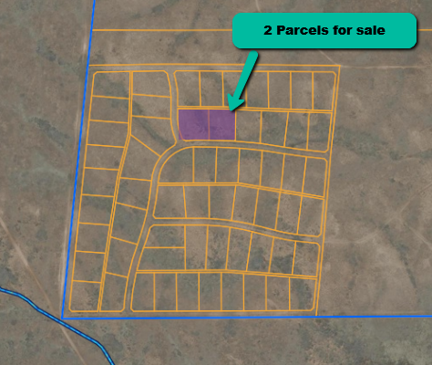
2.25‑Acre Ranch Lots (Combined) – Lew King Ranchettes, Yavapai County, AZ
Cash price for both parcels: $37,800 Financed price: $41,800 (with 20 % down, 12.99 % APR)
2.25€‘Acre Ranch Lots (Combined) – Lew King Ranchettes, Yavapai County, AZ
Cash price for both parcels: $37,800
Financed price: $41,800 (with 20 % down, 12.99 % APR)
Property Facts
-
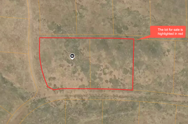
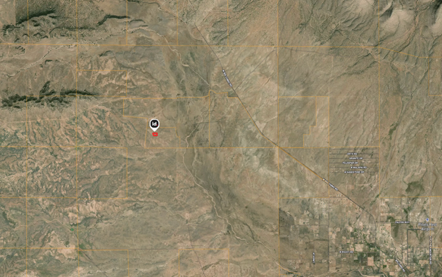
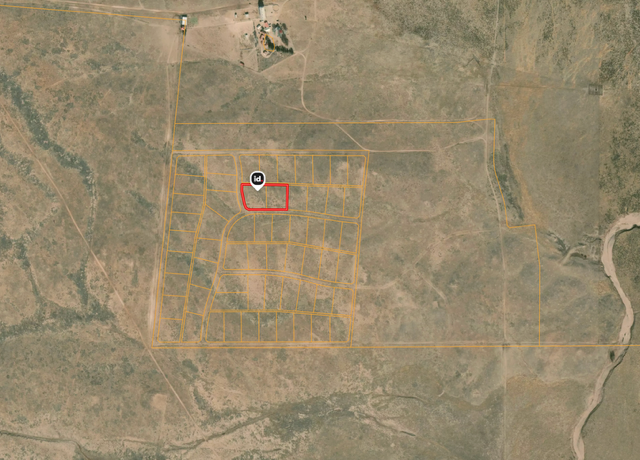
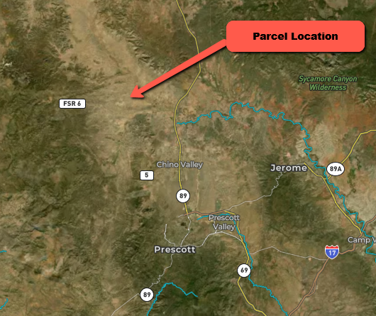
Location: Lew King Ranchettes subdivision (no HOA) near Ash Fork/Paulden, Yavapai County, Arizona
-
Parcels: 303€‘05€‘049 (Lot 29) – 1.07 acres / 46,609 sq ft; coordinates 34.95681° N, €‘112.60149° W
id.land
303€‘05€‘050 (Lot 30) – 1.18 acres / 51,401 sq ft; coordinates 34.95681° N, €‘112.6022° Wid.land
-
Total Size: ≈2.25 acres (approx. 98,010 sq ft)
-
Legal Description: Lew King Ranchettes Lot 29 Cont 1.07 Ac and Lot 30 Cont 1.18 Ac
id.land
-
Zoning/Land Use: Vacant Land (Nec) ideal for a ranch, weekend getaway or future home (verify use with county)
-
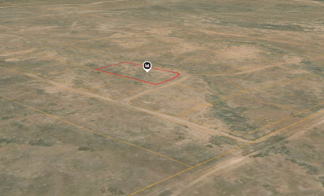
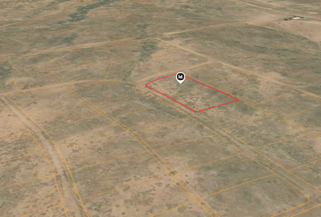
Topography: Mostly level to gently rolling high€‘desert terrain. Land ID’s 3D view shows open grassland with distant hills; no major ravines or flood areas.
-
Road Access: Both lots front a county€‘maintained dirt road leading to Purple Heart Trail/I€‘40. Approx. 200€‘ft road frontage with ~230€‘ft average depth per lot (combined frontage ~400 ft).
-
Utilities: No utilities are installed; buyers may use off€‘grid solutions (well/septic/solar). There are nearby homes in the subdivision, suggesting power lines are in the area—buyer should verify.
-
Annual Taxes: about $15.66 per lot (≈$31.32 total)
-
Parcel ID & County Records: ID numbers 303-05-049 & 303-05-050. Yavapai County, Tax Code Area 5140
Map & Terrain Insight
-
Paved vs. Dirt: The parcels front a well€‘graded dirt road that connects to paved county roads and Interstate 40.
-
Boundaries & Access: Use the Landglide app to see exact property lines in the field. Copy the GPS coordinates above into Google Maps for turn€‘by€‘turn directions.
-
Surroundings: The area is open ranch land with scattered juniper and pinyon pines. Nearby parcels show minimal development, so you’ll enjoy privacy, dark skies and panoramic mountain and desert vistas.
Research & Comparables
-
LandSearch reports that the average asking price for land in Paulden is about $38,491 per acrelandsearch.com. Recent listings of 2€‘acre parcels in Paulden range from roughly $26,000 to $55,000 (‰ƒ$13k–$27k per acre).
-
At $37,800 cash for 2.25 acres, this property is priced around $16.8k per acre, well below the local average. It offers an affordable opportunity for a pair of adjoining lots.
Nearby Attractions
| Attraction | Description & Appeal | Approx. distance* |
|---|---|---|
| Watson Lake & Granite Dells (Prescott) | A unique lake surrounded by huge granite boulders, offering camping, hiking, rock€‘climbing and photo€‘worthy vistastheoutbound.com. Boating/kayak rentals availabletheoutbound.com. | ~27 mi south |
| Giant Alligator Juniper Trail (Prescott) | Out€‘and€‘back trail through scenic Prescott woodlands; perfect for hiking among old juniperstheoutbound.com. | ~20 mi |
| Watson Lake & Flume Trail Loop | A 4.5 mi loop hugging Watson Lake with granite€‘dell scenery; a great workout—bring water and sunscreentheoutbound.com. | ~27 mi |
| Lynx Lake | A 55€‘acre lake with shady trails and picnic spots; hike around the lake and enjoy fresh high€‘country airtheoutbound.com. | ~32 mi |
| Tuzigoot National Monument (Clarkdale) | Explore an ancient 110€‘room Sinagua pueblo via a self€‘guided half€‘mile looptheoutbound.com. Learn about Native American history. | ~35 mi |
| Robbers Roost (Sedona) | Short hike through red€‘rock country to a cliff€‘side alcove with sweeping views; dramatic Sedona scenerytheoutbound.com. | ~40 mi |
*Distances are approximate driving distances from the property.
Nearby Cities
-
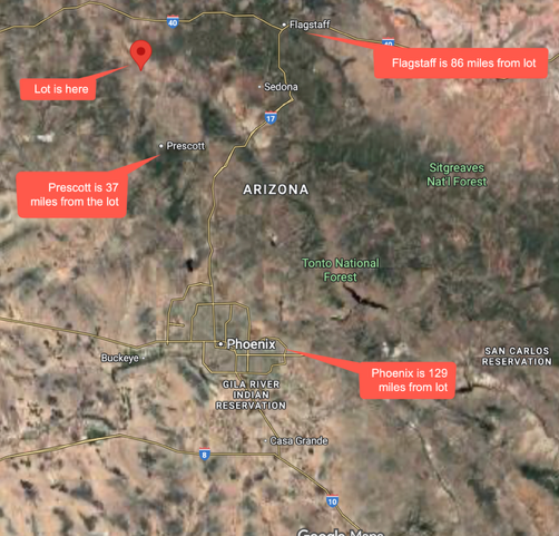
Ash Fork, AZ: ~19 mi (25 min) – nearest services, fuel & groceries.
-
Chino Valley, AZ: ~16 mi (20 min) – larger town with schools, shopping & medical services.
-
Prescott, AZ: ~30 mi (35–40 min) – county seat offering full services, hospitals and historic downtown.
-
Flagstaff, AZ: ~56 mi (≈1 hr) – major city with university, medical center and gateway to the Grand Canyon.
Purchase Options
| Term | Down Payment* | Approx. Monthly Payment† | Details |
|---|---|---|---|
| Cash | — | — | $37,800 total – pay in full and own it outright (plus taxes and recording fees). |
| 24 Months | $8,360 down | ≈$1,627/mo | Payment includes principal + 12.99 % interest, $35/mo servicing fee and property taxes. |
| 36 Months | $8,360 down | ≈$1,164/mo | Same terms; longer amortization reduces monthly cost. |
| 48 Months | $8,360 down | ≈$935/mo | Extended term for the lowest monthly payment. |
*Down payment is 20 % of $41,800 plus $1,500 closing costs and a 4€‘month tax reserve, totaling about $9,870 due at signing.
†Monthly payments include estimated property tax (about $31.32 per year) and the $35 servicing fee; amounts are approximate and subject to final underwriting.
Ϭ Why This Property?
-
Combined 2.25 acres: Two adjacent parcels—keep one, sell one later or enjoy extra space for privacy.
-
Affordable vs. comparables: Priced significantly below the average per€‘acre price in the arealandsearch.com.
-
Easy access: Frontage on a county€‘maintained road with quick connection to Interstate 40.
-
No HOA or covenants: Freedom to build your dream ranch, tiny home or weekend retreat (verify with county zoning).
-
Close to recreation: Minutes from national forests, lakes and historic sites for boating, hiking and exploring.
Ready to explore? Plug the GPS coordinates into Google Maps or use the Landglide app to walk the boundaries and start dreaming.

Map To Property
Property Address:Property Details
- Status: Available
- State: AZ
- County: Yavapai
- Parcel Number: 303-05-049 and 303-05-050
- Size (In Acres): 2.25
- Road Access: Yes - Unpaved
- Electricity: Within 1 mile
Similar properties in the area are listed or have been recently sold for around $49,141.