UTAH Highway 30 frontage Offered at 40% off Fair Market Value!
Only $565/acre! Cash Price $14,900 for 26.38 Acres
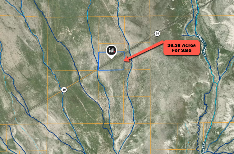
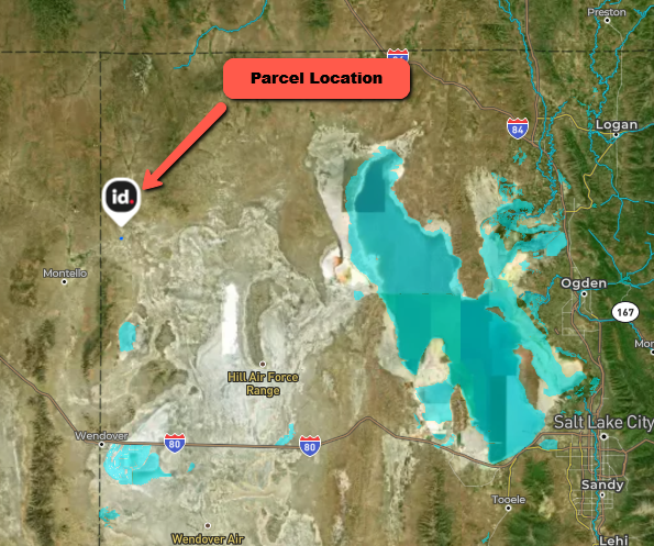
Grouse Creek 26.38-Acre Desert Parcel — Paved Access on SR-30
Bring your dreams to the wide-open deserts of north-western Utah! This 26.38-acre parcel (1,149,113 sq ft) sits directly on paved State Route 30 near Grouse Creek in Box Elder County. The rectangular lot has roughly 1,300 feet of road frontage and extends about 880 feet north-south, offering easy year-round access. With flat terrain and unobstructed views of the surrounding mountains, the property makes a great base for a homestead, agricultural venture, or recreational getaway. It is zoned agricultural with very low taxes (about $24/year) and no HOA or subdivision restrictions. GPS coordinates are 41.40006 N, –113.95181 W—plug them into your phone or use the Landglide app to walk the exact boundaries. The legal description reads “S 2/3 SW/4 NE/4 Sec 19 T8 N R18 W Sim Cont 26.38 Ac.” Utilities are not present; buyers typically use wells, septic systems and solar/ generators.
What Makes This Property Special
-
Paved state highway frontage: SR-30 runs along the southern edge for about 1,300 ft, giving direct access for RVs, trailers or farm equipment; no long dirt roads to reach your land.
-
Quiet desert setting: The land is level and mostly cleared, making building or camping easy. There are no subdivision covenants; you’re surrounded by BLM lands and ranches.
-
Priced below comparables: A nearby 60-acre lot on the same highway is listed at $57,000 (~$950/acre) — this 26.38-acre parcel is offered at just $14,900 cash (~$565/acre) or $17,900 with financing.
-
Low taxes & simple ownership: 2024 assessed value is $2,902 with taxes around $23.69/year. Box Elder County allows agricultural and low-density residential uses.
Nearby Attractions & Distances
-
Sun Tunnels – about 8 miles southwest. These four concrete cylinders by artist Nancy Holt frame the sun on solstice mornings and evenings and are a must-visit for photographers and astronomers.
-
Devils Playground – roughly 25 miles east. Explore granite spires and eerie rock formations that invite rock climbing, ATV riding, and endless photo opportunities.
-
Golden Spike National Historical Park – approximately 74 miles east at Promontory Summit. Walk the original railroad grade and see Victorian-era locomotives where the transcontinental railroad was completed in 1869.
-
City of Rocks National Reserve – about 50 miles northwest in Idaho. This “silent city” of towering spires attracts climbers, hikers and campers with dramatic scenery.
-
Bear River Migratory Bird Refuge – around 94 miles east near Brigham City. These freshwater marshes at the Great Salt Lake’s mouth are a haven for migrating waterfowl and wildlife.
Tremonton is approximately 120 driving miles east for groceries and services; Brigham City (~130 mi) and Salt Lake City (~150 mi) provide larger shopping, medical care and airports.
Payment Options
-
Cash: $14,900 plus closing costs ($1,500) and a four-month tax reserve (~$7.90).
-
Owner financing: Purchase price $17,900 with 20 % down ($3,580) plus closing and tax reserve. Interest rate 12.99 %, taxes included. A $35 monthly loan-servicing fee applies.
| Term | Monthly principal & interest | Monthly tax & servicing fee | Total approximate payment |
|---|---|---|---|
| 24 months | $680.73 | $35 + $1.98 | ≈$717.71/month |
| 36 months | $482.43 | $35 + $1.98 | ≈$519.40/month |
| 48 months | $384.10 | $35 + $1.98 | ≈$421.07/month |
Down payment plus closing costs and tax reserve (≈$5,088) is due at closing. Payments above are estimates and subject to final underwriting.
Make It Yours
If you’ve been waiting for an affordable acreage with paved access and spectacular desert views, this lot deserves your attention. Use the GPS coordinates and Landglide to explore the boundaries and picture your cabin, RV pad or small ranch. Call or email today for more details or to secure this unique parcel!
Map To Property
Property Address:Property Details
- Status: Available
- State: UT
- County: Box Elder
- Parcel Number: 02-060-0005
- Short Legal Description: S 2/3 Sw/4 Ne/4 Sec 19 T8 N R18 W Slm Cont 26.38 Ac
- Annual Property Taxes: 23.69
- Size (In Acres): 26.38
Similar properties in the area are listed or have been recently sold for around $20,863.
Buy this property today for just $14,900! (You save $5,963)
To purchase this property today call Michael Peters, Silver Bear Land LLC at 307-456-6264 now!